Protecting Northern Colorado’s water starts upstream—in the forests, rivers, wetlands, and headwaters that collect and deliver the water our communities depend on every day. That’s why Peaks to People Water Fund is joining with Northern Water and the Colorado Forest Restoration Institute (CFRI) at Colorado State University on Northern Water’s Forest Health and Watershed Treatment Area Prioritization Project.
Lake Granby is the third largest body of water in Colorado. It was created by the erection of Granby Dam, completed in 1950, as part of the Bureau of Reclamation’s Colorado-Big Thompson Project. Photo: Peaks to People
Together, we will expand the Watershed Investment Tool (WIT) into Grand County and Colorado’s West Slope headwaters, helping identify wildfire-related threats to source watersheds and drinking water infrastructure, prioritize forest treatment areas (treatments such as mechanical thinning and/or prescribed fire), and guide strategic investments across the broader source water system that supports communities, farms and businesses throughout Northern Colorado.
Developed by Peaks to People and CFRI, the WIT is a science-based decision-support tool that connects potential wildfire behavior, post-fire erosion, sediment delivery to water infrastructure, and associated economic consequences to help answer a critical question: Where can limited resources have the greatest impact?
This expansion will extend the tool beyond its current footprint to include Northern Water infrastructure across three connected watershed systems: the Cache la Poudre, Big Thompson, and Colorado headwaters. By incorporating West Slope source watersheds and infrastructure, the WIT will provide a more complete picture of wildfire risk to Northern Water’s interconnected water supply system, which delivers water from Colorado River headwaters across the Continental Divide to communities throughout northeastern Colorado.
Why This Matters
Northern Water manages several large regional water supply projects including the federally-owned Colorado-Big Thompson (C-BT) Project, the Windy Gap Project, and the Northerns Integrated Supply Project. These systems connect landscapes and communities on both sides of the Continental Divide. A substantial portion of the region’s water supply originates in Colorado River headwaters on the West Slope and is conveyed through an interconnected network of reservoirs, tunnels, canals, streams, and diversions before reaching Horsetooth Reservoir, Carter Lake, and water users across Northern Colorado.
Our watersheds face increasing pressure from severe wildfire, drought, post-fire flooding, erosion, and sedimentation. When high-severity wildfire occurs, impacts can move rapidly downstream—carrying ash, debris, and sediment into rivers, reservoirs, diversion structures, and canals. The result can be damaged infrastructure, reduced storage capacity, higher treatment costs, and threats to reliable water supplies.
Proactive forest and watershed restoration can reduce these potential post-fire impacts before disaster strikes, but effective action requires strong science, shared priorities, and coordinated investment.
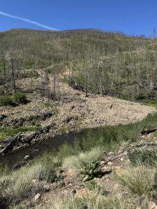
Debris Flow in Willow Creek drainage post East Troublesome Fire. Photo: Peaks to People
“We need to ensure we are directing limited funds to the highest priority areas within our watersheds and to better demonstrate return on investment to our leadership as well as our constituents. By expanding Peaks to People’s Watershed Investment Tool, we can more efficiently target projects that reduce wildfire risk and improve watershed resilience for the one million people that we serve on the Front Range and downstream communities who depend on these watersheds. It also helps us better understand our priorities so we can partner more effectively with key landowners and implementers on the ground.” Kimberly Tekavec, Senior Source Water Protection Specialist, Northern Water
A Bigger Tool for a Bigger Challenge
The expanded WIT will help partners evaluate wildfire risk to water supplies across a broader geography while accounting for the infrastructure systems that deliver water throughout Northern Colorado.
The project will:
Assess potential post-fire erosion, sediment delivery, and downstream impacts to water infrastructure.
Identify and prioritize high-impact forest treatment opportunities across the three watersheds.
Evaluate return on investment by comparing forest treatment costs to the avoided costs of post-fire management responses (e.g. reservoir dredging) to support strategic watershed health investments.
Develop implementation pathways that align project priorities, funding opportunities, and partnerships.
The result will be a stronger framework for moving from risk assessment to on-the-ground implementation.
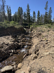
Post fire runoff and debris flows degrade stream banks and impede riparian function. Photo: Peaks to People
“Expanding the WIT into Colorado River headwaters allows us to evaluate how post-fire watershed impacts in West Slope source areas could propagate through Northern Water’s interconnected system and influence operations, storage, and delivery to East Slope users and reservoirs. It also enables consistent comparison of investment opportunities across all three watersheds using a shared decision framework.” Allie Rhea, Watershed Scientist and Spatial Analyst, Colorado Forest Restoration Institute
Science, Partnership, and Practical Decision-Making
One of the WIT’s greatest strengths is its ability to connect wildfire risk to downstream water impacts. The tool recognizes that not
all infrastructure contributes equally to water collection and distribution systems. By accounting for the location, function, and relative importance of reservoirs, diversion structures, canals and pipelines, and treatment infrastructure, the WIT helps identify where forest management can provide the greatest benefit per dollar invested.
Sean Henry, Environmental Planning Department Manager, Northern Water
“Northern Water’s primary collections watersheds are located on the West Slope within Grand County. Expansion of Peaks to People’s Watershed Investment Tool will allow us to create an in-depth geographic prioritization of these watersheds, quantify potential risks, site projects, and provide a cost-benefit analysis to our senior management and board. This quantitative geographic analysis will allow us to better educate stakeholders, gain project support (internal and community), and best direct available funding to gain the most bang for our buck.” Sean Henry, Environmental Planning Department Manager, Northern Water
CFRI will lead technical modeling and analysis, building on years of applied wildfire and forest science expertise. Northern Water will contribute infrastructure data, operational priorities, and source water protection expertise. Peaks to People will help connect the science to partnerships, funding opportunities, and implementation strategies.
Together, this collaboration reflects a shared commitment to protecting the forests and watersheds that sustain Northern Colorado’s communities, economy, and quality of life.
From Readiness to Action
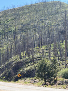
East Troublesome Fire impacts 6 years post fire. Photo: Peaks to People
Recent Colorado wildfires have demonstrated how quickly watershed conditions can change—and how costly recovery can be once a fire has occurred.
By expanding the WIT now, we will have better information to identify shared priorities, coordinate investments across jurisdictions, and advance projects that reduce water supply risk before the next wildfire.
At Peaks to People, we believe the best time to protect water is before it is at risk. Through this partnership with Northern Water and CFRI, we are helping build a more resilient water future Across the Divide.
Sign up to receive news and updates on how peaks to people is protecting the health of our watersheds.Sign up today
If you're interested in making a donation, you can do so by following the link below: