FAQs
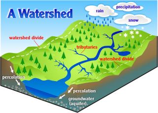 A watershed, sometimes referred to as a drainage basin, is an area of land where all of the water that is under it, or drains off of it collects into one location such as a stream, river, lake or wetland.
Image Credit: Delaware County Conservation District
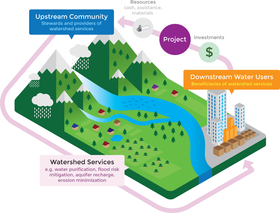 A water fund is a mutually beneficial partnership between the downstream communities who depend on water and the people upstream who manage the land. Through the water fund mechanism, water users invest in the restoration of the lands that produce the water they depend on. Implementers, such as watershed coalitions, conservation districts and numerous other public and private entities can utilize the Water Fund mechanism to support their work on the ground.
Watershed Investment Programs (WIPs) are initiatives designed to deliver ecosystem services (e.g., filtration, flood control, etc.) by investing in the protection or restoration of nature.
WIPs aim to deliver water security and associated co-benefit outcomes via a defined portfolio of Nature based Solutions (NbS) interventions within a specified service area (the “NbS Investment Portfolio”). A WIP is a programmatic approach for delivering Watershed Investments, which are defined as transactions between a service provider and payer or beneficiary where financial or economic value is exchanged for activities or outcomes associated with the maintenance, restoration, or enhancement of natural areas considered important for watershed services (Forest Trends 2016).
LEARN MORE HERE.
Peaks to People Water Fund aims to protect water resources in the Cache la Poudre and Big Thompson watersheds in Northern Colorado. The Big Thompson Watershed includes 173 lakes, 974 total river miles, and 530 perennial river miles, encompassing 7,212 watershed acres and more than 900 square miles. The Cache la Poudre River Watershed drains approximately 1,056 square miles above the canyon mouth west of Fort Collins, Colorado.
Collaborative Conservation is an approach to natural resource management that emphasizes the cooperative efforts of diverse stakeholders—such as government agencies, non-profit organizations, private landowners, community groups, scientists, and businesses—to achieve shared conservation goals. It prioritizes inclusivity, partnership, and a balance between ecological health, economic viability, and community well-being. By integrating local knowledge with scientific expertise, collaborative conservation seeks to address complex environmental challenges, foster sustainable practices, and build resilient ecosystems and communities.
Our process for identifying and engaging partners is rooted in fostering relationships with organizations committed to protecting forests, watersheds, and communities. Together, we create impactful, large-scale solutions that enhance forest resilience and protect water supplies.
LEARN MORE HERE.
We follow a strategic process to ensure we continually add value to the important restoration work already underway in Northern Colorado.
- Engage in collaborative conservation efforts with a diverse group of stakeholders, stewards and beneficiaries.
- Obtain new and significantly scaled sources of funding for forest health treatments.
- Identify priority places for restoration and cost-effective risk reduction treatments.
- Create consistency in monitoring standards and measures of success.
- Track and report on the outcomes of forest health treatments in the watersheds.
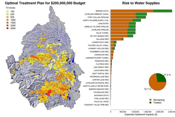 The Watershed Investment Tool (WIT) is a risk-based assessment and planning tool designed to estimate the benefits of forest fuels reduction and leverage this information to optimize fuel treatment type and location. The tool analyzes pre-treatment forest fuel conditions, determines the optimal treatment methods (such as prescribed fire and/or mechanical thinning), and helps stakeholders establish project goals. It also analyzes the results of each project to provide measurable outcomes of success and inform future decisions. Try it out and see for yourself how it works!
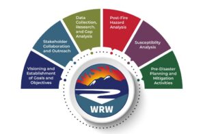
Colorado’s Wildfire Ready Watersheds (WRW) initiative, developed by the Colorado Water Conservation Board (CWCB), supports a proactive approach to identifying and addressing post-wildfire hazards and impacts. The WRW Wildfire Ready Action Plan (WRAP) framework describes and provides guidance on how to refine the susceptibility evaluations for local communities.
The WRAP framework is meant to serve as a guide for best planning practices in advance of a wildfire and will also support post-fire mitigation strategies. This includes guidance on data collection and GIS preparedness, permitting and compliance, stakeholder development, hazard analysis and evaluations, engineering, as well as pre-and post-fire management actions.
Peaks to People is the Project Sponsor for a Wildfire Ready Action Plan (WRAP) being developed for the Big Thompson watershed, in collaboration with the Big Thompson Watershed Health Partnership (BTWHP), to better understand and plan for post-fire hazards. LEARN MORE HERE.
Wildfire mitigation actions are on-the-ground treatments of forested properties implemented to reduce the threat of wildfire. These actions can take place before, during or after a wildfire has occurred. The Colorado State Forest Service (CSFS) is an excellent resource for residents who want to gain more information and take steps to decrease the threat of wildfire to their property.https://csfs.colostate.edu/wildfire-mitigation/
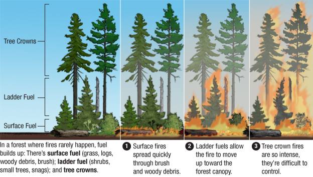 An active crownfire is a fire that spreads to the tops of the trees and spreads from tree top to tree top. Ladder fuels move the fire from the ground to the crown.
Graphic Source: U.S. Forest Service
Credit: Adam Cole, Nelson Hsu / NPR
The WUI is the portion of a landscape where structures and other human developments meet, or intermingle with, undeveloped wildlands. If your home is located in the natural vegetation of Colorado’s grasslands, shrublands, foothills or mountains, you live in the wildland-urban interface (WUI) and are inherently at risk from a wildfire. Learn what steps to take to protect your home from the devastating effects of wildfire. https://static.colostate.edu/client-files/csfs/pdfs/FIRE2012_1_DspaceQuickGuide.pdf
It’s the buffer you create between a building on your property and the grass, trees, shrubs, or any wildland area that surround it. This space is needed to slow or stop the spread of wildfire and it protects your home from catching fire—either from direct flame contact or radiant heat. Creating defensible space is essential to improve your home’s chance of surviving a wildfire. Defensible space is also important for the protection of the firefighters defending your home. Learn all about it at: http://www.readyforwildfire.org/Defensible-Space/
YES. Wildfire can significantly alter the hydrologic response of a watershed to the extent that even modest rainstorms can produce dangerous flash floods and debris flows. For information on what to do if you live in a recently-burned area where debris flows are possible, and there is a rainstorm – before, during, and after, download the National Weather Service Post Wildfire Flash Flood and Debris Flow Guide https://www.wrh.noaa.gov/…/DebrisFlowSurvivalGuide.pdf
In severe, slow-moving fires, the combustion of vegetative materials creates a gas that penetrates the soil profile. As the soil cools, this gas condenses and forms a waxy coating. This causes the soil to repel water – a phenomena called hydrophobicity. This hydrophobic condition increases the rate of water runoff. Percolation of water into the soil profile is reduced, making it difficult for seeds to germinate and for the roots of surviving plants to obtain moisture. Learn more at https://extension.colostate.edu/soil-erosion-control-after…/
In forestry, treatments focus on reducing overgrown forests by thinning trees in a method that promotes natural habitats, but mitigates the risk of fire by leaving less available fuels to burn in the event of a fire. Depending on the specific treatment plans for each site, trees may be:
~Felled and put into a burn pile
~Removed for other use
~Treated with a prescribed burn
All treatment plans are thoroughly vetted and discussed with landowners, contractors, and investors prior to the start of a project.
It’s a management unit within which a management treatment may occur, similar to a stand in size (1-100+ acres) but defined more by operational boundaries (natural topographic breaks, roads,property boundaries) than by vegetation as it may contain multiple forest types or stands.
“Feasible wildfire risk” identifies areas of risk that we are able to treat (some areas have land use and other restrictions that do not allow management).
Canopy cover refers to the amount of ground area covered by tree canopy, expressed as a percentage. For example, 50% canopy cover means that 50% of the ground area is covered by tree canopy. Canopy cover can be measured in the field using a densitometer or via remote sensing.
An active crownfire is a fire that spreads to the tops of the trees and spreads from tree top to tree top. Ladder fuels move the fire from the ground to the crown.
Graphic Source: U.S. Forest Service
Credit: Adam Cole, Nelson Hsu / NPR
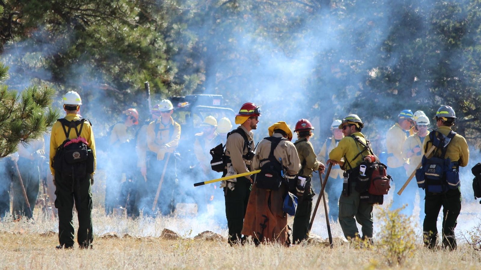 The U.S Forest Service describes a Prescribed Burn as a planned fire used to meet management objectives. The right fire in the right place at the right time. Prescribed burning (also known as a controlled burn) involves careful planning, coordination and monitoring. These planned fires are strategically set by experienced fire professionals to restore and maintain healthy forests and grasslands.
Photo of prescribed burn at Ben Delatour Scout Ranch near Red Feather Lakes Colorado September 2017.
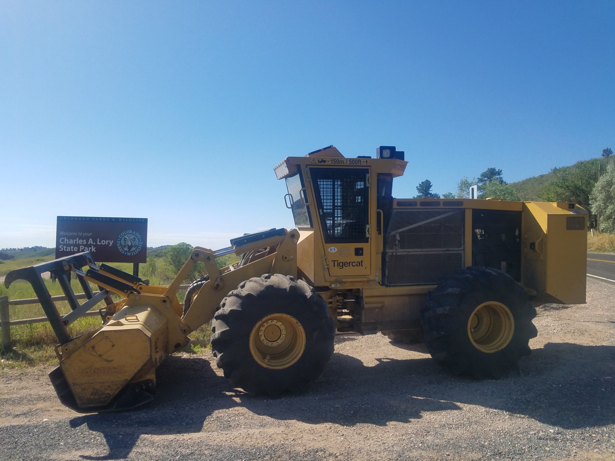 Mastication is a fuel reduction treatment method used in forestry management to reduce wildfire risk, to reduce fuel loadings by returning the forest to natural conditions. Masticating fuels, or mulching the forest, involves the reduction of vegetation into small chunks and is one of the many ways overstocked forest stands are thinned. The benefits include opening the canopy and forest floor which provides the remaining trees access to more nutrients, sunlight and water. Over the past decade, Forest mastication methods have dramatically reduced wildfire hazards and greatly improved forest health. Read all about it at https://www.driforest.com/what-is-forest-mastication
Photo Credit: Colorado State Forest Service
 Piles of woody materials remaining after a forest is thinned are burned to reduce the amount of fuel available for a wildfire to burn.
An acre-foot is the amount of water it takes to cover an acre of land in a foot of water, or 325,821 gallons.